Veggie Voyagers

Couple travelled 30 states and 3 Canadian provinces between 7/07 and 5/08 running their 1987 Ford truck on straight veggie oil. The blog continues with a focus on the natural world and energy politics from a personal perspective

Thursday, August 30, 2012

Save the Peace!

 Finally have made it to the Peace River. How beautiful is the valley below us despite the stiff wind at the over-look. As soon as we started down through the farm land though there started to be signs against "Site C" so when we got to the Visitors' Center at Hudson's Hope I had to find out and what I found was that ever present dagger of pernicious human activity. This valley and actually three contiguous valleys are slated to be flooded for another hydro-electric dam! It doesn't matter that these families have farmed here since the 1800s, that dinosaur fossils are everywhere and yet undiscovered, that First Nations and early settler trade routes were on this river, that it is critical habitat for the bull trout and essential grizzly migration habitat... it's in the final phase of approval. (See www.paddleforpeace.ca : www.keepingthepeace.wordpress.com and check out the Yellowstone to Yukon Conservation Institute for an online petition.)
We drove over the huge earthen dam of Williston Lake (largest lake in Canada) and saw the vast hydro-electric grid there on our way to long, skinny Carbon Lake which we reached with some travail. (I fell asleep during my navigation shift and we rumbled past it.)
 The weather at Carbon Lake was finicky. Wind, spits of rain and an end of summer finality that went with the dried up feel of the lake margins. One thing that was definitely happening though is these little mud colored frogs were trying to make their ways into some sort of frog future (and their desperate and mindless movement reminded me of our human headlong rush to somewhere/something-- yes, the collective; yes, our own.)
 Michael was steadfast in his purpose though and has continued to collect waste restaurant oil and process it. I love his tarp stabilization with the canoe paddles and his ability to weather everything the old truck can throw at him. Improvise and problem solve and get it done.
 This morning we are in Chetwynd, home of famous life sized wood carvings that are mostly fanciful and beautiful. I liked this "builds character" one though... seems like our brains are always getting stacked up with stuff and it is a never completed task for the little voice inside us that is trying to do a good job and make sense of it all.

Monday, August 27, 2012

Sikkani Chief Falls

It's taken us three days to get down to Fort St. John from Fort Nelson.... The straight shot down the Alaska Highway is littered with natural gas activity..housing, well heads, roads, men, trucks. The vast forests appear stunted in size and are unimpeded by logging other than by disease or global warming.... apparently the warmth of the last winter season caused the needles to respond earlier than the roots had come out of icy thaw and the trees died as a result.
Our best stop along the way was at Sikkani Chief Falls which is on terraced cliffs covered in mossy growth, lichen, alders and buffalo berries. Below we could see mountain goats- a male, female and kid on the south lower area by the river and two goats below us on the north. Michael climbed way out over the cataract and scared me to get a shot I'll try to upload. (Having trouble with that today.)
My favorite part of camping above this was the Northern Lights which we were able to see at about 2am as constantly changing beams or light coming from a diffuse cloud of yellowish green. The part that warmed me on that chilly night of multi-millions of stars was seeing the "flames" rising under the low hanging Big Dipper, just like a low flame dances below a pot...
This is the Peace Region. We are seeing the word Peace everywhere and are reminded of human balance in constricted environs even as city life flows back around us. I'm reminded of the wild though by the goat hair bracelet (harvested from the twigs they passed through) that graces my wrist... until we get that shower anyway.

Friday, August 24, 2012

Fort Nelson

 We are in Fort Nelson, east of the Northern Canadian Rockies. It seems to be on a vast plain of arboreal forest. The population is well-to-do and it is nice to have access to a well supplied grocery store, video store, aquatic center... The only problem has been three days of rain. The map shows our route since Prince Rupert and that we are now on a long plunge south, at Mile 300 of the Alaska Hwy. I was definitely sad to move so quickly between Muncho Lake and Summit Pass... these were the areas where I felt the greatest wildness.
The picture below is of a mama caribou and her calf racing for the wood margin. We were at Summit Pass when I took this photo.
... as well as this one of the white fronted geese. What was so special about them is that they winter in the Northern Sacramento Valley so they will get there at some point after we do.
 The birch trees are turning yellow and the yellow sprinkles the hillsides now.
 Three days of rain. Yesterday the fog was so bad we could only see about thirty feet. As we head south I recall that we are still far north of our farthest northerly point, Jasper, in the 2007-2008 Veggie Voyage. The crew and I may be soggy but are still looking forward to clearing skies and adventures to come despite being currently becalmed.

Tuesday, August 21, 2012

Liard to Muncho

 We are in Muncho Lake but since internet is so dear I want to backtrack and will possibly have photos from here in the next post. The whirlpool rapids on the Liard River had striking rock layering. All the rivers we've seen, until the Trout River have been broad, high and fast moving and not really that attractive to try to figure how to boat on. We fantasized about the Trout but really, the put in and take out and amount of time with the meanders made it intimidating too.
The woodland buffalo were almost extinct by 1906 but a small herd of introduced buffalo continue to thrive along the Alaska Highway. We saw over 50, crashed out in the afternoon warmth.
 Michael processed veggie oil above this spectacular falls. You only see the lower segment in this photo... there really was no way to capture the whole thing as trails to the area above don't exist. The area around it has all burned. Fires persist now and are the reason I'm not showing you the jewel-like Muncho Lake... because the air is far too hazy and that's been the way of it for days of travel.
 Yesterday we forked out the money to stay at the Liard River Hotsprings Provincial Park. We walked out there when we first arrived, then after dark and again this morning. There are two pools and the cooler, lower one shown here is completely natural. The upper pool is just about unbearably hot. It was a wonderful place to listen to the stories of locals and people passing through from everywhere imaginable... in all kinds of vehicles and from many different cultures yet we were lucky because there never really were that many people there at any one time.
 Earlier today we walked out to try to see sheep and moose eating the mineral rich banks above the Trout River but just got really close to four grouse (help! ptarmigan?) It's amazing these tame birds survive in the wild.
We'll continue into the Rocky Mountains now and hope the weather holds. Will catch up again from Fort Nelson. p.s. Diesel was 7$ a gallon at Liard Hot Springs Lodge.

Saturday, August 18, 2012

Jade Country to Watson Lake

 The picture above is of our idyllic life aboard the Veggie Voyager. We were at Dease Lake and that was actually after we were at one of the beaver created Gnats Lakes, below, with moose prints everywhere but no Moose to see... We went for a long bike ride along an old railroad grade and came on some Korean men who spoke no English drilling for something...the locals thought Jade. Dease is the Jade Capital of the World but Cassiar also has that distinction, we don't know who is right however. In our own way we ended up with a unique peek into jade country.
 We suddenly blew a radiator hose coming up a grade. Notice how sunny it was? Within a half hour of being pulled off the road here it was raining. Michael fashioned an ingenious inner hose from something else, wrapped the old hose around it tightly with duct tape and we went on to a place called Jade City. The people there were really wonderful and suggested a fellow who is a wrecker in the supposedly abandoned town of Cassiar so we drove up there and it was really unique meeting Judi and Larry in their sled dog, chicken, car/truck etc parts extravaganza high up in mining country. Michael got anti-freeze from them, some more hoses, an antenna and we shared some time listening to their stories of life in the remote mountain terrain with grizzlies and miners.
 Last night we hiked at Boya Lake Provincial Park and then took a hasty swim in the crystal clear waters as a fire raged in the distance. We came through many miles of fire ravaged forests today.
 Also today we made it on across into the Yukon where Michael was able to pick up many gallons of veggie oil from the folks at the restaurant where Highways 37 and 97 junction and we came on to the Alaskan Highway east to Watson Lake, where there are over 71,000 signs from places all over the world, a signpost forest they call it. They are celebrating Discovery Days here in town and so it is time for us to move on... one thing we noticed immediately though is the increased signage, yellow divider line in the highway and increased traffic and population. We sure loved our time on Highway 37 up through the wildlands of British Columbia and it is bittersweet to be headed south from here even if it is on the storied Alcan Highway.

Stewart to Dease Lake

 This is a retrospective from Watson Lake... we couldn't find any internet, radio, cell phone service or news since Hyder-Stewart and frankly, that was ok. It was raining the entire day when we left our little spot along the Bear River in Stewart and we drove more than we usually do after doing our usual chores in the rain in Stewart.
 The next morning at Mehan Lake dawned crystal clear and so we had a number of beautiful days lumbering up Hwy 37, taking time out for exploring on the few bumpy unsealed and unposted back roads.
 One such stop was a lunch and hike on the Forestry Road over the Iskut River.
 The forests became different with lichens and mosses of the muskeg. The land changed as we rolled along, stopping to process veggie oil, hike or camp, depending on the day and access. We saw more bears-- grizzly bear jiggly with fat stores running ahead of us on the back road by Eulue Lake and black bear cutting across the deserted highway in front of us. The road had no signs, no houses, no divider strip... remote and serene and a welcome relief, often festooned with the lowly fireweed but also others-- clover, daisy, coreopsis in the margin to the forests... a soothing reminder that large expanses of open wild space still remain here on the planet we call home.

Monday, August 13, 2012

Stewart-Hyder

 Yesterday was the best wildlife viewing day I ever had. It is true that I got these shots from a viewing platform shared with about 30 other photo snapping tourists but it was still incredible. The grizzly cub was like all children... goofy and playful as his mother moved down "Fish Creek" filled with spawning and dying chum. Seeing a wolf was the most satisfying though... calm but unsuccessful in his half-hearted attempts to catch fish. We were told that the bears prefer the skin and the wolves the heads but that neither will eat carrion. For that there were a number of satiated looking young bald eagles perched in the trees above and of course, gulls.
 After watching the animals and fish for a long time we headed up to the Salmon Glacier, 5th largest in North America. The photo below is the "toe."
 And this photo is from the best viewing at the summit of the road with Sasha looking a little deflated in contrast to the grandeur.
 On the way back down the terrible pitted mining road we stopped again, before visiting Hyder, Alaska, and were treated to a black bear enjoying berries.
We are in Stewart, B.C. It's raining and Michael is processing veggie oil out by the Bear River under a spectacular waterfall. I rode my bike into Stewart, which is very quiet on a Monday, to do laundry and get last provisions before we head away from the coast. Even though this is 70 miles up the Portland Channel to the estuary where this sweet little town (and it's rowdy American twin, Hyder, peaks out from further out to open water,) it's still got the life of the sea in it, but more of mining. The area is rich with present and past mining in the vast mineral rich mountains to the north of here.

Saturday, August 11, 2012

First Nations

 We left Kitimat, Km 0 Hwy 37, in the rain and headed back through Terrace and back onto Hwy 16. We stopped for the night in the ancient lands of the Gitselasu. Reading about their complex and striated society and 5000 years of canyon life around the Skeena River, was really hard to fit with this modern depiction of the clans and long houses. We were alone here until morning when some young girls came to cut the grass.
 The next day we visited the Gitanyow community at dusk. We were just obnoxious taking pictures of these, "the oldest concentration of totem poles still in their original location." Who to ask? How to make it ok? We move through and take images of their clan totems.... what gives us the right? Who are they and who are we? What a remote place to be in-- so near. so far.
 Michael found an amazing place to process veggie oil with the most magnificent views out to the Seven Sisters Peaks. However, he would rather I display this pile of bear leavings on the road so here ya have it... There are plenty more peaks to show you.
 In our ugly American role, after turning north at Kitwanga Junction, we also visited Kitwanga Fort, also called Battle Hill, where a great warrior ingeniously held off hostile attacks in the early 1800s. After that we followed the Kitwanga River farther north up Hwy 37. It feels good to be moving slowly north even as food, propane, veggie oil, radio etc. grows harder and more infrequent to access.

Wednesday, August 8, 2012

Greetings from Kitimat!

 After months of having just this one destination in mind I'm frankly over-whelmed by the issues that flood my mind. The postcard version might say "Greetings from Kitimat, B.C." and have a photo of  whitish bear cubs but this story is even bigger than Kitimat being "ground zero in a race to fuel Asia."
It's about ancient people, the Haisla, who are now, as they always have been, living within a natural world filled with power, creatures and the great connection between the two. On the other side of this white community marina and the Douglas channel, which becomes the Kitimat estuary just inland of this photo, is what the dominant culture has done. It developed hydro-power, built the roads, built the planned community, brought in Alcan which was purchased by British/Australian Rio Tinto (the multi-billion $ miners of just about everything which flourishes where "government is lax, corruption high and business practices poor" in the developing world.) It's home to Shell owned Methanex which sued California under free trade rules when California tried to phase out MTBE, one of their methanol-linked products that's extensively polluted groundwater. It's got it's LNG facility and it's concrete plant and who knows what else... temporary housing for thousands.
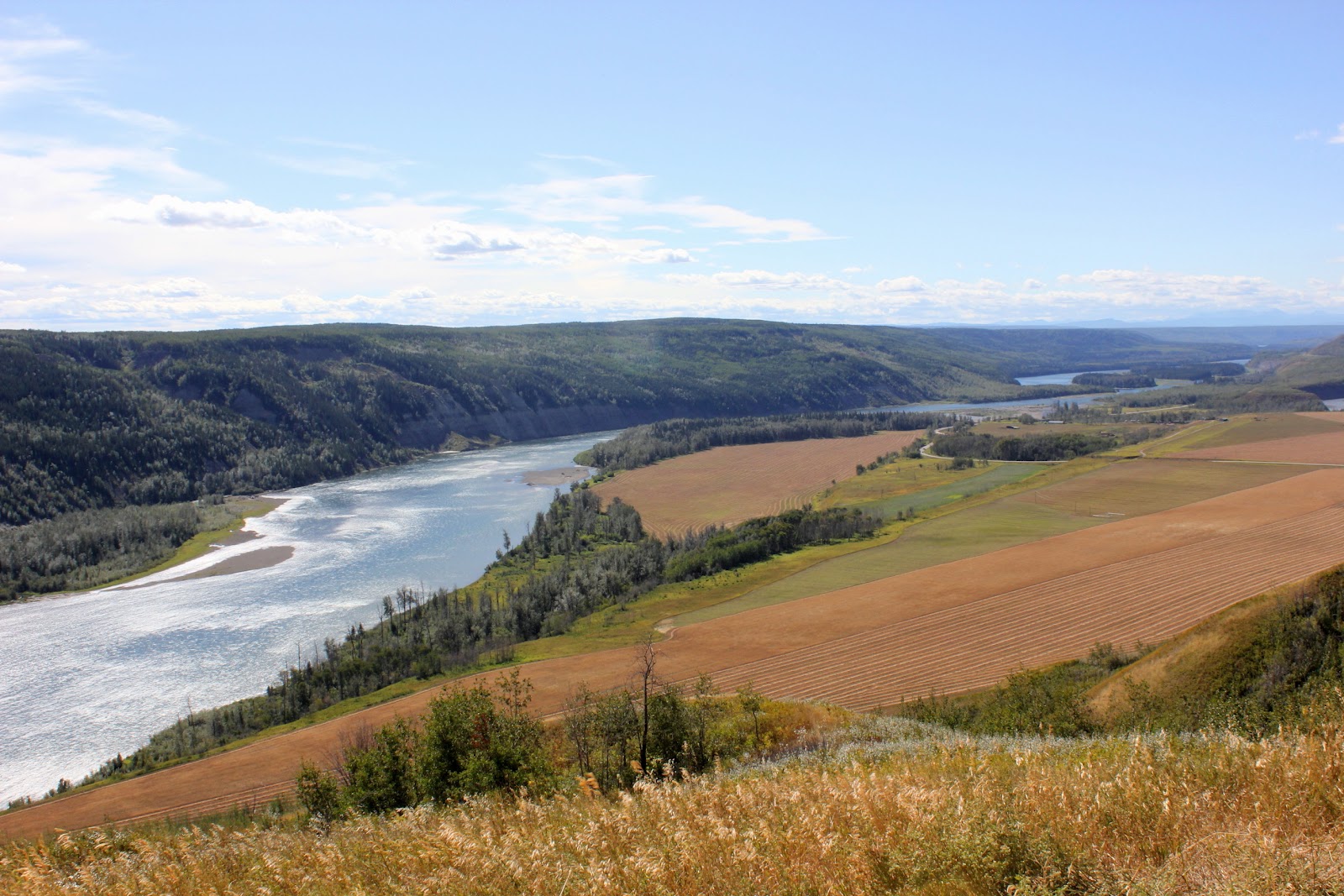
 We got here yesterday afternoon after a swim in Lakelse Lake and last night on our gravel bar along the Kitimat River were shaken by a brilliant lightning storm. In the photo below Michael is on what he called whale rock and beyond him is the estuary... home to 112 bird species in the spring and countless other creatures. We even saw a seal watching us in the river yesterday... It's with newcomers' eyes of wonder and concern we see everything. I can't interview everyone here but take it from the one lifetime resident I spoke with that the local Canadians worry about jobs and are reluctant about the Northern Gateway Pipeline but feel they must have the employment it offers.
 This shot is from Hospital Beach, which is closed, as is the road, quite inexplicably... the Chamber of Commerce said it was for the Rio Tinto Modernization project but that is back beyond the old aluminum plant... Driving to this spot we both felt rather ill with this smoke which constantly flows from this plant. There is a long history of lung cancer in aluminum smelter workers (per a 14 year study of Alcan workers) but there is also a virtual chorus line of polluting industry, intermixed with environmentally sensitive feeder creeks and a fish hatchery on this stretch. I imagine that the Alberta pipeline would find it's way to port from this side of the channel, nestled among the other industry... although this is the westward side of the estuary/channel and the pipeline would be coming from Alberta in the east.
 The Kitimat River Bridge. Huge chum, coho, chinook (?) we saw last night at the hands of fishermen are a fraction of what feeds the forests and the creatures. The Enbridge Northern Gateway pipeline and the threat it poses out along hundreds of miles of channel are a very real risk but the spills in the Kalamazoo River and elsewhere show what may happen in the remote mountains along the course between Alberta and this beautiful sensitive and rugged region. "Jobs" is a real issue but so is the balance with the remaining intact ocean, fresh water, complete cycling multi-species dance of life cycle. I appreciate all the people who are caught up in this multi-billion dollar project but must weigh in finally and forever with this planet that sustains us all... this dirty bitumen oil production is about profits for the few and these few use the needs and fears of working people for their political aims. It just makes me want to lecture, pontificate, cry, scream, dig into the earth and put thinking into reverse. I can't but say, stand with the First Nations people. Fight the Pipelines.

Tuesday, August 7, 2012

Yellowheaders

 On our way eastward from Prince Rupert on the Yellowhead Hwy we didn't get far out of town before being pulled to hike down to Butze Rapids... a rapids both at slack and ebb tides, going east or west depending on the time of day. Here it is slowed just before high tide. The Sitka spruce and deep green of the country are as verdant as you would find in any rainforest except on this trail there were warnings that wolves may kill your dog so be careful.
 We made it as far as Exchamsiks River Boat Launch, where the Exchamsiks flows into the mighty Skeena (a good mile wide in places and running fast a glacier gray color and sadly with a body in it as one swimmer was lost yesterday upriver from where we were.) It's fed by high snow melt that flows in thin white ribbons from these great coastal mountain peaks.
 While Michael processed veggie oil amidst the fisherpeople I rode my bike to the Exchamsiks Provincial Park which just has a short loop of interpretive trail--- the camp grounds were removed because the human activity threatened the old growth Sitka Spruce grove... I was wandering off trail for views up to the sheer cliff above the river (looking for mountain goats,) when I saw this little memorial without an interpretive sign. I imagine it was for a pet or a love that died... but this brought me back to Hiroshima Day and I sent my love to all those killed then and ever after in all wars. It had been my intention to be at the Pipeline Action Camp by this date but we just can't rush anymore. We gave short shrift to the Olympic Peninsula and to Vancouver Island. The staggering beauty here can not be denied or over-shot.
However, from our campsite on the confluence of the Zymacord and Sheena Rivers, we had to admit to being pretty wussed-out by the mosquitoes which find their way in each time the door opens as well as possibly through some vents. We are both pretty recovered, here in Terrace for errands, but realize this is something we will be faced with and the moski quite a challenge.

Sunday, August 5, 2012

Inside Passage to Prince Rupert

 We took the Northern Expedition Ferry from Port Hardy to Prince Rupert yesterday. It was an uncharacteristically sunny day-- really almost hot out of the wind except for fog in the Queen Charlotte Strait. It was a seven deck ferry with 200 international passengers and was quite comfortable. The treat of our lifetimes.
 Most of the channels were quite wide but apparently in 2009 one of these ferries ran aground. Below is the Douglas Channel that tankers would take to and from Kitimat if the bitumen/oil-shale/tar sands Endridge crude is allowed to be shipped to China. Just from the little bit of dense fog we experienced I'd say it could be easy to run aground with the number of turns necessary to reach beyond multiple islands to the Queen Charlotte Sound and open waters. For us the water was smooth and conditions were as perfect as they have ever been-- crew kept remarking about it.
 We were exhausted from a long day of peering out at the surrounding wooded mountains and watching for whales. (I just saw four.) The sunset, which was at about 9:30 pm was quite beautiful in Chatham Sound and quite the exception apparently. This morning in Prince Rupert's Safeway parking lot dawned drizzly and fog bound as is normal in this rainiest of Canada's cities.
 So this isn't a picture from today but alas the computer wouldn't cough up any totem pictures or the sign post showing that we are just 27 miles from the Alaska border. We have a fuel leak to fix and need to process veggie oil to get to our next destination but I wanted to show you Michael's ingenious veggie oil carrying capacity before urging you to have a thoughtful Hiroshima remembrance tomorrow and on Nagasaki Day. Only peace, only thoughtful preservation of earth resources and species will allow humans to survive the next epoch. Ever grateful, we voyage east after visiting a few more Asian restaurants.